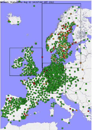
Figure 1: Map of the GNSS ground stations used by the E-GVAP data analysis centres and for which tropospheric delays are computed (status: 12 Augustus 2010)
|
E-GVAP is based on a combination of centralised functions, which are carried out by the E-GVAP management team, and distributed functions, which are handled by the European National Meteorological Service (ENMS) members in collaboration with their geodetic colleagues.
The E-GVAP objective is achieved in close collaboration with the geodetic community who operate the 11 analysis centres that provides operationnaly the NRT tropospheric delay estimates. ROB maintains one of these GNSS analysis centres.
In practice, thanks to the coordination of E-GVAP, the observations from permanent GNSS tracking stations distributed all over Europe (Figure 3) are now routinely analysed each hour by a set of voluntary GNSS data analysis centres. Each of these GNSS data analysis centres provides E-GVAP in near real-time with tropospheric Zenith Total path Delays (ZTD) from a European regional sub-network. These GNSS delay data are then used by the European National Meteorological Services (ENMS) for weather forecasting and nowcasting applications. Altogether, the GNSS data analysis centres process observations from about 1250 unique sites (status: August 2010). Over the last years, this number has grown with more than 200 new sites a year to reach as today 2100+ sites.
The GNSS observation sites used in E-GVAP mainly belong to two categories of GNSS networks: on one hand, to international public networks such as the International GNSS Service (IGS) network and the EUREF Permanent Network (EPN), and on the other hand to national and/or private networks such as the ones operated by National Mapping and Cartographic Agencies (NMCA).
|
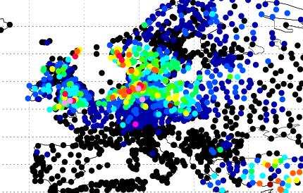 Figure 2a: Observed rain
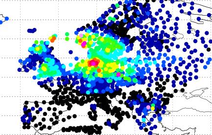 Figure 2b: Forecast rain with GNSS
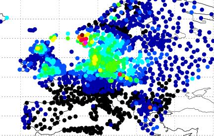 Figure 2c: Forecast rain without GNSS
|
The following example is taken from the E-GVAP website. These figures show a case with significant improvement of a precipitation forecast when ground-based GNSS observations are included to calculate the exptected future weather. The top-right picture shows the observed rain over a 12-hour period. Below are the predicted amounts over the same period with (left picture) and without (right picture) GNSS observations respectively. Green, yellow, red, and violet colors indicate severe large amounts of rain, with violet being the highest.
|