|
Royal Observatory of Belgium
Solar-Terrestrial Centre of Excellence
Belgian Science Policy Office
|
E-GVAP Activities at the ROBSince the end of the 90's, the GNSS team of the Royal Observatory of Belgium (ROB) contributed to several European projects aiming at investigating the benefits of using GNSS observations for climatological and meteorological applications (COST 716, TOUGH and E-GVAP). At the end of the COST 716 Action and during the TOUGH project, the ROB has setup an analysis centre providing the European meteorologists with operational GNSS tropospheric delay estimates updated every hour. Since then, this analysis center has been further developed and maintained to participate in the various phases of the E-GVAP program. Today, the E-GVAP research and developments are carried out at the ROB in the framework of the Solar-Terrestrial Centre of Excellence (STCE) which is a project funded by the Belgian Federal Science Policy (BELSPO).
Figure 1: Picture of the Royal Observatory of Belgium
Data Flow and Local DatabasesThe data flow of the GNSS observations one of the most important issue acting on the stability of the GNSS processing systems. Therefore, much efforts have been spent in the stability and reliability of the data flow by setting up a local daily+hourly RINEX database integrating as many redundency links as possible to collect very quickly the RINEX files. The local RINEX database includes all European stations from the EUREF Permanent Network (EPN) and the International GNSS Service (IGS). It also includes the stations from several national networks (e.g. in Belgium, France, Netherlands and U.K.). The large extend of the network processed by ROB ensure the stability of the absolute tropopshere estimation. Finally, a similar local database was setup to collect all orbits and products from the IGS (IGU, IGR, Final) necessary to the processing. GNSS Meteorology Processing Systems
The GNSS Meteorology analyses carried out at ROB are based on an advanced usage of the Bernese GPS software v5.0. It is based on double-differenced GPS-only observations, which eliminate/mitigate many errors. The ROB processing systems uses IGS products (Ultra-Rapid ones except for the post-processing systems which uses the IGS Final Products). As of today, ROB develop and maintains 3 processing systems, each of them specific objective(s) and products:
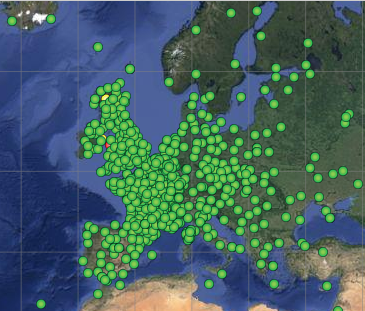
Near Real-Time (Hourly) AnalysisThe main goal of the Near Real-Time Processing Systems is to provide European meteorologists with hourly-updated Zenith Tropospheric path Delays (ZTD) for data assimilation in Numerical Weather Prediction (NWP) models. This processing systems is run once per hour (at H:18), uses hourly RINEX observations and provide GPS-based ZTD with a time reolution of 15 minutes. The processing system analyses the observation of about 380 stations each hour (see Figure 2) in less than 15 minutes. The latency of this product (i.e. the age of the product w.r.t. the oldest GNSS observation analysed) is less than 1h30m.
Figure 2: GNSS stations included in the Near Real-Time Processing System (Only station in Europa are shown).
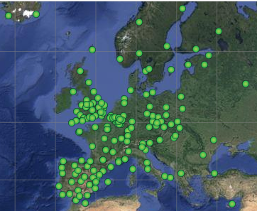
(Status: 20 January 2014) Sub-Hourly AnalysisThe main goal of the Sub-Hourly Processing Systems is to provide support to high-resolution rapid-update NWP models and to nowcasting applications by estimating Zenith Tropospheric path Delays (ZTD) several times per hour. This processing systems is under development and will run four times per hour (at H:01, H:16, H:31 and H:46). It uses real-time GNSS observations and provides GPS-based ZTD with a time reolution of 15 minutes. The processing system analyses the observation of about 180 stations each hour (see Figure 3) in less than 10 minutes. The latency of this product (i.e. the age of the product w.r.t. the oldest GNSS observation analysed) will be less than 30 minutes.
Figure 3: GNSS stations included in the Sub-Hourly Processing System (Only station in Europa are shown).
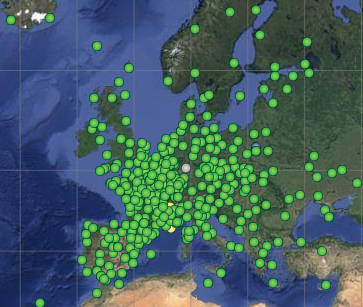
(Status: 20 January 2014) Post-Processing AnalysisThe main goal of the Post-Processing Systems is to provide precise coordinates for all stations used in the Near Real-time and Sub-Hourly Analysis. The determination of precise coordinate is a mandatory step before estimating the troposphere parameters. The post-processing analysis is run once a day with a latency of 5 days. It uses the IGS Rapid products, daily RINEX files and state-of-the-art processing techniques (not applicable in (near) real-time analysis). The processing system analyses the observation of about 840 stations (see Figure 4) in about 12-15 hours. It is re-run once when the final IGS products are available (latency ~ 21 days). In addition to precise coordinates, the post-processing analysis provides also precise tropospheric estimates with a time resolution of 1 hour that can be use for validation and re-analyses purposes.
Figure 4: GNSS stations included in the Post-Processing System (Only station in Europa are shown).
(Status: 20 January 2014)
This page is still under construction. Please come back later... |